
Rip Currents – Trouble from Far Away Storms
It is the middle of summer. A beautiful beach day along the Jersey Shore. Temperatures are sweltering in the 90s with lots of humidity. Water temperatures offshore are a refreshing 15 to 20 degrees cooler. The temptation for many is to jump right in. However, mid-summer is also peak season in the Atlantic, and beachgoers need to take precautions before going in. The reason is rip currents: trouble from far away storms.
Rip currents, rough surf, long period swells are symptoms along coastal areas from a powerful storm well out to sea. Even though a hurricane is well offshore, it could still pose a problem for eager beachgoers. Imagine a major hurricane in the Central or Western Atlantic far away from land. It may be an eventual threat to Bermuda, the Canadian Maritimes, or perhaps the Azores, but not to the United States coastline from Maine to Texas.
Even though the U.S. shoreline is spared the worst effects of a major hurricane, there are still things to worry about. Major hurricanes are known for their storm surge and dangerous waves. The combination of powerful winds and low pressure stirs up the ocean. Wave heights from a large and powerful hurricane that is Category Three or higher on the Saffir-Simpson Scale can be as high as 40 to 50 feet in the open Atlantic.
These high waves are pushed toward the coast by the hurricane’s circulation. When those waves get to the shore, they create swells and rip currents that make the water on a pleasant beach day treacherous. A powerful hurricane in the Western Atlantic is much like tossing a huge boulder in the middle of a pond. When people toss stones into a pond or lake, they create a ripple effect.
Hurricanes are like huge boulders dropped into the middle of the Atlantic. In this case, the ripples created by these powerful storms are the large waves that are driven to the coast. The waves may dissipate somewhat before reaching the shore, but they’re still capable of creating dangerous surf. Rough surf in places such as Manasquan or Barnegat Light along the Jersey Shore can be at least 3 to 6 feet above normal. Sometimes, the wave heights could be as high as 9 feet.
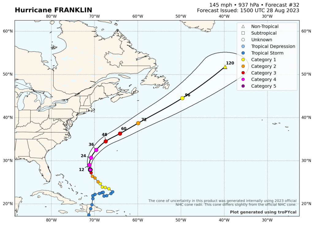
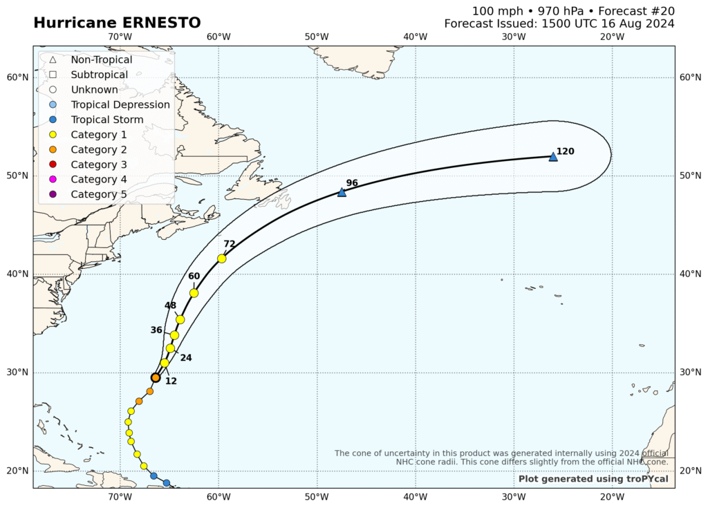
Over the past two years, there have been powerful far away hurricanes that have generated lots of rough surf along the Jersey Shore. In August 2023, Hurricane Franklin stirred up chaotic waters off the Jersey Shore at Manasquan Inlet. Last year it was Hurricane Ernesto that created havoc up and down the Jersey Shore from Sandy Hook to Long Branch to Long Beach Island.
On August 28, 2023, Franklin rapidly intensified into a high-end Category Four Hurricane with 145 mile per hour winds. The minimum central pressure dropped to 937 millibars or 27.67 inches. Although, Franklin’s diameter was only 370 miles its winds and pressure made up for it to stir up very dangerous waves up and down the East Coast of the United States. Franklin’s winds grew to 150 mph and produced rip currents that prohibited swimming and even closed beaches along the Jersey Shore going into the busy Labor Day Weekend.
During the weekend of August 16-18, 2024, Ernesto was a vast Category Two Hurricane with winds of 100 miles per hour and a minimum central pressure of 970 millibars, or 28.65 inches. More importantly, though, Ernesto had tropical storm force winds that extended 275 miles and hurricane force winds reaching out 75 miles. The storm’s total diameter was 700 miles. A big boulder spinning in the Western Atlantic. By August 18th, three deaths were attributed to rip currents generated by waves from Ernesto in the Carolinas.
I was at the Jersey Shore when both of these storms were spinning in the Atlantic. I witnessed powerful 6 to 9-foot waves from Franklin at Manasquan Inlet on August 30, 2023. One person who was fishing on the jetty was almost pulled in by the tremendous current in the inlet. Last year, I visited several locations along the Jersey Shore and while the wave heights may have not been as high as those from Franklin, they still made it too dangerous to go into the water.
If you do plan to head into the water this summer, pay attention to the wave forecasts. In addition, follow the latest advisories from the National Hurricane Center whenever there are storms in the Atlantic. Watch for heavy surf advisories and rip current statements from your local National Weather Service Office. Make sure that there is a lifeguard on duty and it is safe to go into the water.
Another thing to check out before heading to the beach is NOAA’s rip current information at https://www.noaa.gov/jetstream/ocean/rip-currents and https://oceanservice.noaa.gov/education/tutorial_currents/03coastal3.html. The National Hurricane Center also posted a Rip Current video presentation on YouTube for Hurricane Preparedness Week 2025.