Skip to content
Hurricaneville

Hurricaneville

Your Source for Hurricane Information

  • Home
    • About Our Guide
    • Support GWCHurricaneville
      • Breathe Better with Navage – Get $20 Discount
      • Donate via Cash App
      • Donate via Venmo
      • Shop WeatherFlow – Smart Stations and Weather Stations – Save 10% with code GWCHURRICANEVILLE
    • Storm Advisories and Discussions
      • Erin – Atlantic – Latest Advisory, Recon, and Discussion
    • Tropical Weather Outlooks and Discussions
      • Atlantic Tropical Weather Outlook and Discussion
      • Central Pacific Tropical Weather Outlook and Discussion
      • Eastern Pacific Tropical Weather Outlook and Discussion
    • 2025 Atlantic Hurricane Seasonal Forecasts
    • Atlantic Hurricanes – Ten Year Average
    • Atlantic Hurricane Seasons – By the Numbers
      • The 2024 Atlantic Hurricane Season – By the Numbers
      • The 2023 Atlantic Hurricane Season – By the Numbers
      • The 2022 Atlantic Hurricane Season – By the Numbers
      • The 2021 Atlantic Hurricane Season – By the Numbers
      • The 2020 Atlantic Hurricane Season – By the Numbers
    • Storm Names
      • Atlantic Tropical Storm and Hurricane Names
      • Atlantic Retired Storm Names
      • Eastern Pacific Tropical Storm and Hurricane Names
      • Retired Eastern Pacific Storm Names
  • Hurricanes 101: The Basics
    • Origins of Hurricanes: Where Storms Form
    • Stages of Tropical Development
    • Evolution of a Hurricane
    • Eyewall Replacement Cycle
    • Key Factors in Tropical Development
    • Factors That Hinder Development
    • Storm Components – Parts of a Hurricane
    • Saffir-Simpson Scale
    • Atlantic Hurricane Season – Statistical Peak
    • Hurricane Impacts
    • Common Storm Tracks
    • Common U.S. Landfall Areas
  • Blog
    • Tracking the Tropics
      • Tracking the Tropics – August 21, 2025
      • Tracking the Tropics – August 18, 2025
      • Tracking the Tropics – August 17, 2025
    • GWCHurricaneville – Weather Blogosphere
  • Preparedness and Safety
    • Know Your Watches and Warnings
    • Hurricane Safety Tips
    • Rip Currents – Trouble from Far Away Storms
    • Most Vulnerable U.S. Cities – Hurricanes
  • Historic Hurricanes
    • Category Five Hurricanes – Atlantic Basin
      • Category Five Hurricanes – Longest Lasting
      • Category Five Hurricanes – Lowest Pressure
      • Category Five Hurricanes – Peak Winds
      • Category Five Hurricanes – U.S. Landfalls
    • Hurricane Rankings
      • Atlantic Hurricanes – Highest Storm Surge
      • Atlantic Hurricanes – Landfalls by State
      • Atlantic Hurricanes – Most Tornadoes Spawned
      • Costliest Atlantic Hurricanes
      • Deadliest Atlantic Hurricanes
      • Largest Atlantic Hurricanes
      • Strongest Atlantic Hurricanes
      • Rainfall from Tropical Systems at GWC
    • Articles
      • The Great Hurricane of 1821
      • The Great Miami Hurricane of 1926
      • The Labor Day Hurricane of 1935
      • The Long Island Express of 1938
      • Remembering Hurricane Gloria
      • Remembering Hurricane Floyd
      • Hurricane Irene Wallops Bahamas and Northeast
      • Isaias Packs a Punch
      • Hurricane Henri Hammers Northeast
  • Links
    • Greg’s Weather Center
    • MapRoom+
    • National Hurricane Center
    • Tropical Meteorology Project – Colorado State University
    • Hurricane City
    • Hurricane Track
    • Mike’s Weather Page
    • Tropical Tidbits
    • Accu-Weather
    • Fox Weather
    • The Weather Channel
    • Weather Nation
  • Home
  • Storm Components – Parts of a Hurricane

Storm Components – Parts of a Hurricane

Footage of Tropical Storm Isaias from South Plainfield, NJ in August 2021.

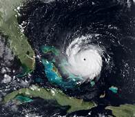
At Left: A satellite image of Hurricane Andrew prior to landfall in the Bahamas and South Florida in 1992.

Now, that we’ve discussed the basics of hurricanes, where they form, their stages of development, and what factors influence their development or decay, it’s time to take a look at what storm components or parts make up a well-developed hurricane. Below, are the most common components of a hurricane.

Eye – Is the center of circulation, and area of lowest pressure within a hurricane. Within the eye of a hurricane, you will encounter clear skies and calm winds. However, don’t let that fool you because once the eye passes your area, the other side of the storm will arrive, and the stormy weather will continue.

Eye Wall – This is the narrow area of intense thunderstorms that surround the eye of a hurricane. In this region, you will encounter the most ferocious portion of the storm with the highest winds it can muster.

Central Dense Overcast – Or, CDO, as it is commonly known, is the mass of embedded clouds that make up the inner portion of the hurricane. This contains the eyewall, and the eye itself. The classic hurricane contains a symmetrical CDO, which means that it is perfectly circular and round on all sides.

Outflow – This is the outer fringe of a hurricane that serves as a very important element in hurricane development. That is because the outflow represents all the energy being released by the hurricane. A powerful hurricane always has good outflow.

  • BlueSky
  • Facebook
  • Instagram
  • LinkTree
  • Threads
  • Twitter
  • YouTube

Copyright © 2026 Hurricaneville.

Theme: Oceanly by ScriptsTown