Skip to content
Hurricaneville

Hurricaneville

Your Source for Hurricane Information

  • Home
    • About Our Guide
    • Support GWCHurricaneville
      • Breathe Better with Navage – Get $20 Discount
      • Donate via Cash App
      • Donate via Venmo
      • Shop WeatherFlow – Smart Stations and Weather Stations – Save 10% with code GWCHURRICANEVILLE
    • Storm Advisories and Discussions
      • Erin – Atlantic – Latest Advisory, Recon, and Discussion
    • Tropical Weather Outlooks and Discussions
      • Atlantic Tropical Weather Outlook and Discussion
      • Central Pacific Tropical Weather Outlook and Discussion
      • Eastern Pacific Tropical Weather Outlook and Discussion
    • 2025 Atlantic Hurricane Seasonal Forecasts
    • Atlantic Hurricanes – Ten Year Average
    • Atlantic Hurricane Seasons – By the Numbers
      • The 2024 Atlantic Hurricane Season – By the Numbers
      • The 2023 Atlantic Hurricane Season – By the Numbers
      • The 2022 Atlantic Hurricane Season – By the Numbers
      • The 2021 Atlantic Hurricane Season – By the Numbers
      • The 2020 Atlantic Hurricane Season – By the Numbers
    • Storm Names
      • Atlantic Tropical Storm and Hurricane Names
      • Atlantic Retired Storm Names
      • Eastern Pacific Tropical Storm and Hurricane Names
      • Retired Eastern Pacific Storm Names
  • Hurricanes 101: The Basics
    • Origins of Hurricanes: Where Storms Form
    • Stages of Tropical Development
    • Evolution of a Hurricane
    • Eyewall Replacement Cycle
    • Key Factors in Tropical Development
    • Factors That Hinder Development
    • Storm Components – Parts of a Hurricane
    • Saffir-Simpson Scale
    • Atlantic Hurricane Season – Statistical Peak
    • Hurricane Impacts
    • Common Storm Tracks
    • Common U.S. Landfall Areas
  • Blog
    • Tracking the Tropics
      • Tracking the Tropics – August 21, 2025
      • Tracking the Tropics – August 18, 2025
      • Tracking the Tropics – August 17, 2025
    • GWCHurricaneville – Weather Blogosphere
  • Preparedness and Safety
    • Know Your Watches and Warnings
    • Hurricane Safety Tips
    • Rip Currents – Trouble from Far Away Storms
    • Most Vulnerable U.S. Cities – Hurricanes
  • Historic Hurricanes
    • Category Five Hurricanes – Atlantic Basin
      • Category Five Hurricanes – Longest Lasting
      • Category Five Hurricanes – Lowest Pressure
      • Category Five Hurricanes – Peak Winds
      • Category Five Hurricanes – U.S. Landfalls
    • Hurricane Rankings
      • Atlantic Hurricanes – Highest Storm Surge
      • Atlantic Hurricanes – Landfalls by State
      • Atlantic Hurricanes – Most Tornadoes Spawned
      • Costliest Atlantic Hurricanes
      • Deadliest Atlantic Hurricanes
      • Largest Atlantic Hurricanes
      • Strongest Atlantic Hurricanes
      • Rainfall from Tropical Systems at GWC
    • Articles
      • The Great Hurricane of 1821
      • The Great Miami Hurricane of 1926
      • The Labor Day Hurricane of 1935
      • The Long Island Express of 1938
      • Remembering Hurricane Gloria
      • Remembering Hurricane Floyd
      • Hurricane Irene Wallops Bahamas and Northeast
      • Isaias Packs a Punch
      • Hurricane Henri Hammers Northeast
  • Links
    • Greg’s Weather Center
    • MapRoom+
    • National Hurricane Center
    • Tropical Meteorology Project – Colorado State University
    • Hurricane City
    • Hurricane Track
    • Mike’s Weather Page
    • Tropical Tidbits
    • Accu-Weather
    • Fox Weather
    • The Weather Channel
    • Weather Nation
  • Home
  • 2025
  • August
  • 21
  • Tracking the Tropics – August 21, 2025
Category Two Hurricane Erin

Tracking the Tropics – August 21, 2025

Posted on August 21, 2025August 21, 2025 By Hurricaneville
Tracking the Tropics
Category Two Hurricane Erin
Hurricane Erin remains a Category Two storm with 100 mph winds and a cloud canopy that has expanded to 1,000 miles across.

Erin Remains a Vast Category Two Hurricane

Hurricane Erin remains a vast Category Two Hurricane as it moves up the Eastern Seaboard on this Thursday afternoon.  Maximum sustained winds have decreased to 100 miles per hour while its minimum central pressure has dropped to 952 millibars or 28.12 inches of Hg.  Meanwhile, three other disturbances are also being watched in the Atlantic with Invests 90L and 99L having the best chance to develop.  Finally, the Eastern Pacific shows signs of becoming active again.  Let’s take a look around in this latest edition of Tracking the Tropics.

Hurricane Erin

The key story now with Erin is its massive size.  With a diameter of over 800 miles, tropical storm force winds extending 500 miles across, and cloud cover extending some 1,000 miles across, Erin is stirring up the waters from Florida to Maine.  

A high rip current risk remains in effect for the East Coast of the United States from north of Miami, Florida to the southern border of Maine in New England.  Storm surge levels range anywhere from 1 to 3 feet in the Mid-Atlantic to 2 to 4 feet along the Outer Banks of North Carolina.

As of the 11:00 AM EDT advisory from the National Hurricane Center, Erin is still a formidable storm at Category Two strength on the Saffir-Simpson Scale.  Maximum sustained winds have slackened to 100 miles per hour while its minimum central pressure has risen to 952 millibars, or 28.12 inches.  Erin is moving more rapidly to the north-northeast at 18 miles per hour. Erin’s diameter has swelled to 1,000 miles including its cloud canopy.  

Watch footage of the Nor’easter-like conditions along Rartian Bay at Aberdeen, Keyport, and Union Beach, New Jersey from the easterly fetch created by Hurricane Erin to the south and high pressure to the north on Wednesday evening, August 20th.

Hurricane-force winds now reach out some 105 miles from the eye while tropical-storm-force winds extend another 320 miles from the center.  Looking at the latest vortex message, the eye of Erin is now negligible.  Tropical Storm Warnings are in effect from Beaufort Inlet, North Carolina to Chincoteauge, Virginia, on the southern tip of the Delmarva Peninsula.

A Tropical Storm Watch remains in effect for Bermuda, but the vast size of the storm is bringing tropical storm conditions to the island.  This development will likely force the government of Bermuda to upgrade the watch to a warning at some point during the day on Thursday.  A Storm Surge Warning is in effect from Cape Lookout to Duck, North Carolina.  Wave heights at Nag’s Head, North Carolina are between 12 and 14 feet.

Erin Producing Dangerous Surf Up and Down the Mid-Atlantic Coast

On Tuesday evening, Greg’s Weather Center and Hurricaneville traveled down to Manasquan, New Jersey to check out the surf conditions there.  Only surfers dared to take on the building waves from the pressure gradient produced by the combination of strong high pressure to the north and Hurricane Erin to the south.

Wave heights at that point were likely around 6 feet.  People on the beach stood in awe at the power of Mother Nature.  Yesterday, those wave heights continued to grow.  Many beaches along the Jersey Shore as well as beaches in Delaware and as far south as Ocean City, Maryland were closed to swimming.   

The wave heights along the Mid-Atlantic from the southern end of the Delmarva Peninsula in Virginia to Long Island.  The National Weather Service office in Mount Holly, NJ has issued a High Surf Advisory in effect until 8:00 PM on Friday for the Delaware Beaches and Atlantic and Coastal Cape May, Coastal Ocean, and Eastern Monmouth counties.

Watch footage of the dangerous surf along the Jersey Shore at Manasquan Beach on Tuesday evening, August 19th.

In addition, there is also a Coastal Flood Warning in effect for these areas until early Saturday morning at 2:00 AM.  This portion of the Mid-Atlantic coast is expected to see large breaking waves as high as 7 to 12 feet on Thursday, and 6 to 9 feet on Friday.  A High Rip Current Risk remains in effect as well.

With such a powerful and massive storm stirring up the ocean, it will take some time for the dangerous surf and rip currents to wind down.  So, if you are planning to go down the shore this weekend, please monitor the latest weather reports and check with local authorities.  Otherwise, stay out of the water.

Four Disturbances in the Atlantic

There are now four tropical features in the Atlantic that are being monitored by the National Hurricane Center on this Thursday afternoon.  There is now a disturbance in the Central Atlantic that is located some 1,200 miles to the southwest of the Azores.  

Atlantic Tropics - August 21, 2025

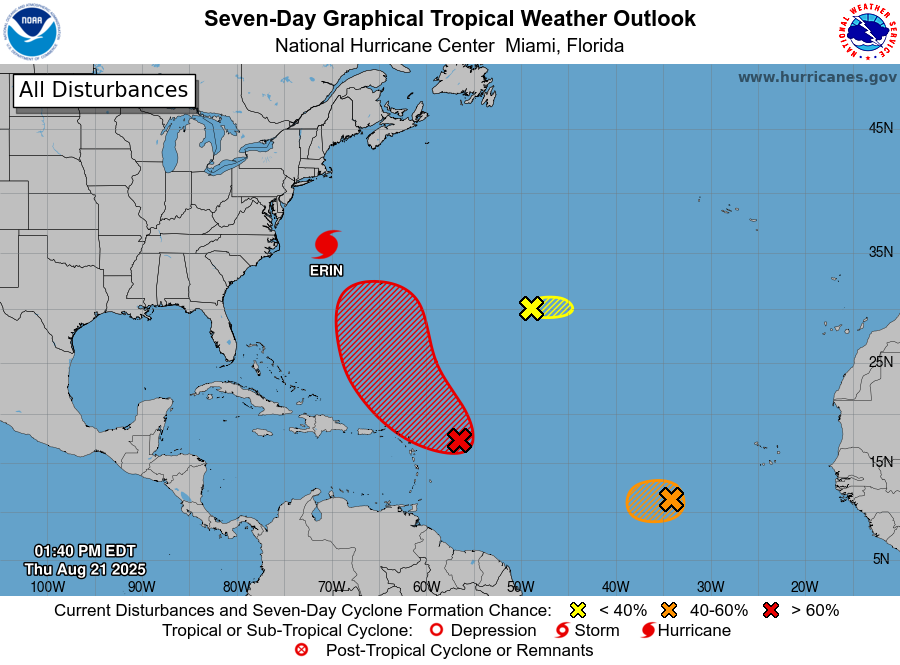
This small area of low pressure is producing very little in convection and is in a location where conditions are marginally favorable for development.  Meanwhile, the disturbance near the Leeward Islands has been designated Invest 90L and has a 50 percent chance of formation over the next 48 hours and a 70 percent chance over the next 7 days.

Finally, there is still Invest 99L, which continues to head westward in the Eastern Atlantic.  The disturbance still has a medium or 40 percent chance of development over the next 48 hours to a week.  The Atlantic remains the busiest of the basins in the Western Hemisphere, but the Eastern Pacific is showing signs of becoming active again.

Eastern Pacific Beginning to Wake Up Again

While the Central Pacific remains tranquil, the Eastern Pacific is showing signs of waking up again.  According to the NHC, an area of low pressure is likely to form this coming weekend off the coast of Southwestern Mexico.  The disturbance has a medium chance of about 40 percent of developing over the next 7 days.

Watch the 21-minute movie of the rough surf and high waves at Manasquan Beach on August 19th.

Post navigation

❮ Previous Post: Tracking the Tropics – August 18, 2025

GWCHurricaneville Follow

Following weather and hurricanes for the Garden State since 1996. Received Minor in Meteorology from Rutgers University in 2004.

hurricaneville
hurricaneville GWCHurricaneville @hurricaneville ·
21h

The high temperature at Greg’s Weather Center in South Plainfield, NJ on Monday was a brisk 57° after a morning low of 35 for a diurnal range of 22°. #njwx

Reply on Twitter 1983144015055802415 Retweet on Twitter 1983144015055802415 Like on Twitter 1983144015055802415 X 1983144015055802415
hurricaneville GWCHurricaneville @hurricaneville ·
21h

Catastrophic Hurricane #Melissa has moved into historic territory this morning. The storm now ranks 8th behind Hurricane Camille on the all time list of intense hurricanes in terms of pressure at https://hurricaneville.com/category-five-hurricanes-atlantic-basin/#CATFIVEMINPRESSURE. #tropics #atlantic

4

Reply on Twitter 1983141551715852612 Retweet on Twitter 1983141551715852612 Like on Twitter 1983141551715852612 X 1983141551715852612
hurricaneville GWCHurricaneville @hurricaneville ·
21h

Nor’easter is expected to bring 2 to 3 inches of rain to Greg’s Weather Center in South Plainfield, NJ and surrounding areas in Northwestern Middlesex County. #njwx #noreaster

Reply on Twitter 1983138653061669048 Retweet on Twitter 1983138653061669048 Like on Twitter 1983138653061669048 X 1983138653061669048
Retweet on Twitter GWCHurricaneville Retweeted
nhc_atlantic National Hurricane Center @nhc_atlantic ·
26 Oct

26 October 5PM EDT: Major Hurricane #Melissa is forecast to bring Life-threatening and Catastrophic flash flooding and landslides in portions of Jamaica and southern Hispaniola through mid-week. For the latest information visit http://hurricanes.gov

Reply on Twitter 1982557802800574545 Retweet on Twitter 1982557802800574545 248 Like on Twitter 1982557802800574545 668 X 1982557802800574545
Load More

No comments to show.

Archives

  • August 2025
  • June 2025
  • May 2025
  • BlueSky
  • Facebook
  • Instagram
  • LinkTree
  • Threads
  • Twitter
  • YouTube

Copyright © 2025 Hurricaneville.

Theme: Oceanly by ScriptsTown