

Erin Ramps Back Up to Category Four
Hurricane Erin continues to be the focus in the Atlantic Basin on Monday afternoon. Erin has ramped back up to Category Four on the Saffir-Simpson Scale. After completing its eyewall replacement cycle on Sunday, the reorganized storm has restrengthened while continuing to get larger in size. There is also a disturbance in the Eastern Atlantic that will likely develop over the next week. Let’s take a look at what’s happening with Erin right now as well as other things occurring in the tropics.
Hurricane Erin
Erin remains the big story throughout all of the tropics in the Western Hemisphere. The season’s fifth named storm, first hurricane and major hurricane went through a reorganization phase in the form of an Eyewall Replacement Cycle after becoming a Category Five Hurricane on Saturday morning. The storm weakened and was downgraded to a strong Category Three Hurricane with 125 mile per hour winds on Sunday.
The reorganization phase concluded by late Sunday afternoon to Sunday evening, and Erin began to ramp back up in intensity at that point. By early Monday morning, Erin reclaimed Category Four status with 130 mile-per-hour winds. The strengthening didn’t stop there as Erin continued to grow not only in terms of intensity, but more importantly, in terms of size.
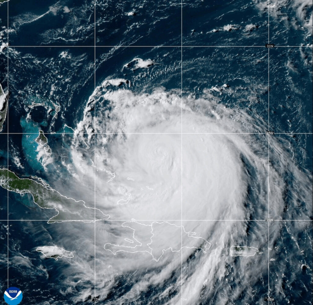
As of the 5:00 PM EDT advisory from the National Hurricane Center, Erin has become stronger Cat 4 storm. Maximum sustained winds had increased back up to 140 miles per hour while its minimum central pressure had returned to 937 millibars, or 27.67 inches. Erin is moving slowly to the Northwest at 10 miles per hour. In addition, the storm’s diameter had swelled to 400 miles.
Hurricane-force winds now reach out some 80 miles from the eye while tropical storm-force winds extend another 230 miles from the center. Looking at the latest vortex message, the diameter of Erin’s eye is now 40 miles across. Tropical Storm Warnings remain in effect for the Turks and Caicos Islands and the Southeastern Bahamas. A Tropical Storm Watch continues to be in effect for the Central Bahamas.
Despite the rampant misinformation being circulated regarding Erin’s future track, the official forecast from the National Hurricane Center continues to be consistent and spot on. Erin will not directly affect either the East Coast of the United States or Bermuda. However, the storm is expected to continue to expand and produce high waves, which will result in rough surf and rip currents for the East Coast.
East Coast Braces for High Waves and Rough Surf from Erin
With Erin’s vast wind field continuing to grow, its diameter is forecast to be as vast as 600 to 700 miles by the time it makes its closest approach to the Eastern Seaboard of the United States. Rip currents have already been a problem up and down the East Coast. Lifeguards in New Hampshire have had to make over 100 water rescues as a result of strong rip currents from another storm system last week. Two people died from drownings along the Jersey Shore in the past seven days.
Conditions are expected to be the most treacherous along the Outer Banks of North Carolina. Waves there are forecasted to get as high as 15 to 20 feet by Wednesday night into Thursday morning. As a result, Dare County, North Carolina has been placed under a State of Emergency, and ordered a Mandatory Evacuation of Hatteras Island on Sunday.
Further up the coast in the Mid-Atlantic, tidal flooding is expected along the Potomac River and Chesapeake Bay later this week. The combination of the swells from Erin coupled with a new moon will cause wave heights to be as high as 10 to 12 feet in the Delmarva Peninsula and Cape May County, New Jersey by Thursday morning.
For the coastal counties of Monmouth, Ocean, and Atlantic in New Jersey, waves are likely to be anywhere from 6 to 9 feet as of this time. Currently, the entire Jersey Shore as well as the Delmarva and the East Coast of Florida is under a high risk for rip currents. If you plan to head down to the beach this week, stay out of the water.
East Atlantic Disturbance More Likely to Develop
Looking beyond Hurricane Erin in the Atlantic, there is another disturbance that is lurking further to the east. A large tropical wave that moved out into the Eastern Atlantic late last week has continued to move westward along the Intertropical Convergence Zone.
Located around 33 degrees West Longitude, the wave is producing a limited amount of disorganized showers and thunderstorms according to the National Hurricane Center. However, the disturbance is in an area that is currently favorable for development and could become a tropical depression or storm over the next seven days.
Eastern and Central Pacific Remain Quiet
Both the Eastern and Central Pacific basins remain quiet on this Monday afternoon. No tropical formation is expected in either of these regions over the next seven days.