Hurricane Irma Begins Her Assault on Florida
Category Four Storm Makes Landfall in Florida Keys
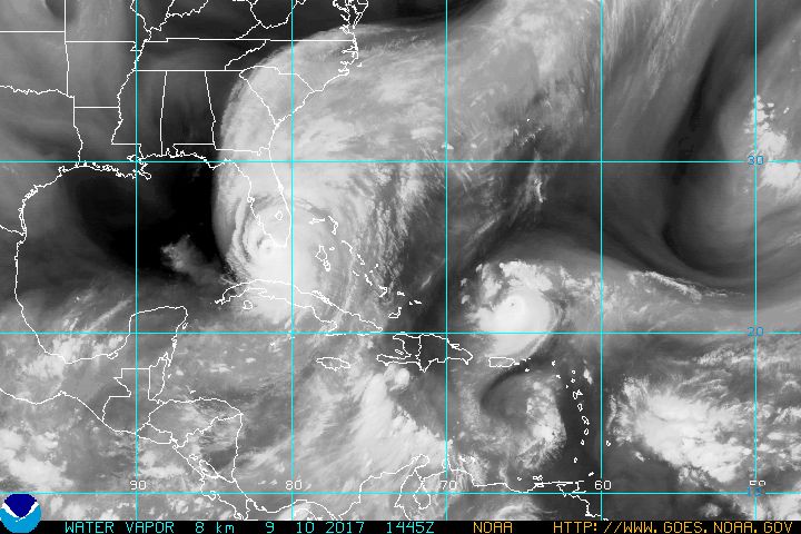
Water vapor satellite imagery depicts Hurricane Irma, which is still a powerful and large Category Four storm as it makes landfall in the Florida Keys and moves north toward Tampa, Florida on Sunday morning. Photo courtesy of NOAA.
If you are in South Florida and the Florida Keys, Hurricane Irma is here. The storm made the first of what is likely to be multiple landfalls along the Florida coastline when it came ashore in Cudjoe Key in the middle Florida Keys at about 9:10 AM on Sunday morning. The storm did re-intensify a little with winds increasing to 130 miles per hour to make it a Category Four Hurricane on the Saffir-Simpson Scale prior to landfall.
The fact that Irma is only a minimal Category Four storm is of little consolation to those trying to ride it out as well as the media covering it. CNN has been providing live coverage all morning for the most part, and the conditions even on the eastern coast of the Florida Peninsula have been rough. Reporters Brian Todd, Kyung Lah, Derek Van Dam, and John Berman of CNN have been dealing with hurricane conditions with winds gusting to as high as 100 miles per hour in Miami Beach.
The Miami Herald is reporting that Key West is under water. Bill Weir, another CNN reporter has been dealing with very intense weather conditions in Key Largo. At 10:36 AM, Berman reported that there is a crane that has cracked in downtown Miami as a result of the high winds being funneled through the skyscrapers in the city. So, basically put, the entire area of South Florida from the Florida Keys eastward to Miami Beach, West Palm Beach, Fort Pierce, and Fort Lauderdale, are all feeling hurricane conditions.
Naples is forecast to see a storm surge between 10 to 15 feet above normal according to the National Hurricane Center, and residents there may be wondering why that hasn’t happened yet. It is because that surge won’t come in until the storm passes, and the surge comes in on the backside of the system later today. Tampa is in the crosshairs of this storm. Although the forecast pinpoints the storm a few miles to the west of the Tampa/St. Petersburg area, that track puts the worst elements of the right front quadrant of the hurricane into this metropolitan area that hasn’t been directly impacted by a major hurricane since 1921.
Currently, as of the 11:00 AM EDT Advisory from the National Hurricane Center, Irma was located approximately 80 miles South-Southeast of Florida, or about 115 miles South-Southeast of Fort Myers, Florida. Maximum sustained winds remain at 130 miles per hour with gusts up to 160 miles per hour. Minimum central pressure is still steady at 933 millibars, or about 27.55 inches of Hg (Mercury). The eye of the storm is about 16 nautical miles wide. Hurricane force winds extend some 80 miles from the eye while tropical storm force winds reach out some 220 miles. The storm has become even larger.
Looking at the Watches and Warnings, a Storm Surge Warning is in effect for South Santee River southward to Jupiter Inlet, North Miami Beach southward around the Florida to the Ocholockonee River, Florida Keys, and Tampa Bay. A Hurricane Warning is in effect for Fernandina Beach southward around the Florida Peninsula to Indian Pass, Florida Keys, Lake Okeechobee, Florida Bay, Cuban provinces of Matanzas and La Habana. A Hurricane Watch is in effect for North of Fernandina Beach to Edisto Beach. A Tropical Storm Warning is in effect for West of Indian Pass to the Okaloosa/Walton County Line, and North of Fernandina Beach to South Santee River. A Tropical Storm Watch is in effect for Bimini and Grand Bahama in the Bahamas.
If it hasn’t already, Hurricane Irma will be moving out over the Florida Bay, which is a very warm body of water near the extreme Southeastern corner of the Gulf of Mexico. Irma should remain out over water for a few hours so further intensification is possible although there has been no significant drop in pressure and the satellite imagery of the storm suggests no significant strengthening for now. It should weaken slightly to a Category Three Hurricane over the next 12 hours, and only weaken to about 125 mile per hour winds. The storm will then move northward and feel the effects of the interaction with the Florida coast as well as increasing shear from the southwest.
By this time on Monday morning, Hurricane Irma is forecast to be a strong Category One Hurricane with 90 mile per hour winds. Then the storm will move inland over the Big Bend area of Florida, and head northward into Southern Georgia, where it should rapidly weaken to a tropical storm and then a depression before becoming post tropical in about three days from now. The storm is expected, however, to leave behind tremendous problems in its wake. FEMA director, Brock Long told CNN on Saturday, that the storm could leave 3 to 4 million people across Florida without power for up to several weeks. There are also concerns about U.S. Highway 1 out of the Florida Keys, which could be damaged, and leave the residents there isolated from the mainland for some time.
Recalling the Labor Day Hurricane of 1935, the storm was a much smaller, but more potent storm as it came through the Keys. You could probably classify that storm as one like Hurricane Andrew or Hurricane Camille, also both powerful, but small Category Five Hurricanes to make landfall in the United States. The 1935 Hurricane, which had been the standard bearer in terms of power for many decades in the Atlantic and Western Hemisphere until the 2005 Atlantic Hurricane Season, brought 200 mile per hour winds that basically destroyed the Overseas Railroad built by Henry Flagler’s Florida East Coast Railway in 1912.
As mentioned earlier, there are also issues with cranes in the downtown area of Miami. There has been a lot of development there, and that has resulted in a lot of cranes being used in many of the high rise buildings being put up there. It was a huge concern for officials and residents there, and that concern has become reality with the one crane suffering a crack earlier on Sunday morning. The brunt of the hurricane is still to come for much of Florida. Also, keep in mind that we still have Jose to deal with in the Atlantic as well. Hurricane Jose is a Category Four storm as well, and could be another problem down the road. In addition, there is another formidable tropical wave in the Eastern Atlantic near the Cape Verde Islands that might develop over the next five days.
Today, September 10th, is the statistical peak of the Atlantic Hurricane Season historically. September is always a big month for hurricanes, especially the classic Cape Verde storms that are usually the ones like Harvey and Irma that make the headlines in the news. A few weeks ago, there were some that thought that this season might be a bust after all, but now nobody is thinking about that at all. Perhaps, the thought may be that this season could be at least the worst season we’ve seen in the Atlantic since the historic 2005 season.