Hurricane Dorian—More Thoughts
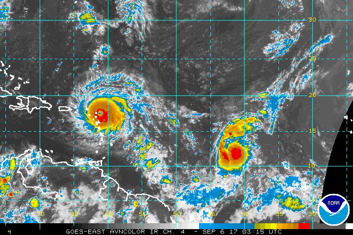
On this early Tuesday afternoon, Dorian has basically grinded to a halt in its forward motion while its winds have decreased some 35 miles per hour from its peak on Sunday afternoon. The storm is still a high end Category Four Hurricane with 150 mph winds and a minimum central pressure of 938 millibars, or 27.70 inches of Hg.
The Northwestern Bahamas have been absolutely pounded as the storm as slowed and its eye crawls across the backbone of Grand Bahama Island towards Freeport. There are outer rain bands currently affecting Eastern Florida. All 67 counties in the Sunshine State are under a State of Emergency while portions of Georgia, South Carolina, and North Carolina are under a State of Emergency as well.
Some 10 million people are under some form of tropical advisory at this time. At this point, the storm is still forecasted to eventually turn north, but Florida is still not out of the woods yet since that turn has not yet started to happen, and it is very possible that Dorian will be much closer to Florida’s East Coast before it does turn northward. It is located about 83 miles from Cape Canaveral, Florida, and about 108 miles from Fort Lauderdale.
Hurricane Dorian is currently going through an eyewall replacement cycle, which is when an outer eyewall forms and replaces the current inner eyewall. This phase is mostly responsible for the storm’s weakening along with the long interaction with Grand Bahama Island as well as some upwelling of colder water. The eyewall replacement cycle usually results with a larger wind field as a result of the conservation of angular momentum.
While the storm is some 500 miles away from the Jersey Shore, the surf has picked up considerably in the past 12 to 18 hours at places like Ship Bottom on Long Beach Island. The surf is much rougher, and more stirred up while the wave frequency and height has increased. There is video proof of this on the GWCHurricaneville Facebook page and twitter feed. Rip tide or rip current advisories are currently in effect for the Jersey Shore through Monday night. Expect the surf and wave action to continue picking up as the storm moves further north and makes its closest approach to the Garden State.
Right now, Southern Jersey is not in the forecast track, but had been in the cone of uncertainty as of Sunday night. Places such as Long Beach Island, Atlantic City, and Cape May could still feel some impacts from Dorian as it heads further north later this week, but areas that are in more immediate danger are along the Southeast Coast from the East Coast of Florida to Southeastern Virginia. Now, let’s discuss some of the things that have been discussed over the last couple of days.
First, there was the talk about the discrepancy regarding the storm when recon detected Category 5 Hurricane winds on the Saffir-Simpson Scale, but was still listed as a Category Four. Here’s the thing: If you have an 18 wheel tractor trailer coming at you, does it really matter how fast it is going at this point? It could be going 50, 65, 70, or 100 mph, it is not really going to matter because if you get in the way of it, it is likely not going to end up well. Then, there is the heavy surf and waves here in Ocean County from Dorian.
Many will say, how is that possible? Simple. It is a ripple effect from the storm. Much like when you drop a stone in a pond. Ripples of water propagate out from where the stone is dropped. So, if you dropped a 200 pound boulder into the middle of a lake, you pretty much have what’s going on in the Atlantic as the result of Hurricane Dorian’s strength, size, and power. I will try to post another blog entry on Tuesday or so. Unfortunately, I am not able to do as much work on the blog and site due to personal commitments such as my work schedule, and other obligations.