Hurricane Irma Closing in on Northern Leeward Islands
Second Major Hurricane of 2017 Strengthens Slightly; Warnings Issued
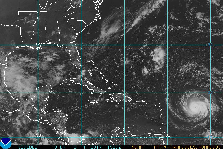
Visible satellite imagery depicts Hurricane Irma, a Category Three storm closing in on the Northern Leeward Islands on early Monday afternoon.
While there has been a tremendous amount of focus on rescue and recovery efforts in Texas in the aftermath of Hurricane Harvey, and the recent escalation of tensions on the Korean Peninsula, the tropics in the Atlantic Basin have continued on its whirling way. Developing in the middle of last week, Hurricane Irma became the fourth hurricane and second major hurricane of the season.
Right now, it doesn’t look likely that Irma will be going away very soon, and it is very likely that it will become a significant threat not only for islands in the Northern Leeward Islands, but also the Bahamas, and somewhere along the United States coastline from New England to the Gulf of Mexico. The track of Irma depends on how far south the storm will go before it makes a turn to the north.
The models, particularly the GFS, have perplexed forecasters not only with different landfalling points, but also very low pressures. One model run of the GFS last night at 18Z, had the minimum central pressure in Irma down to an amazing 857 millibars, and maximum sustained winds near the eye at 157 knots, or about 180 miles per hour by the early morning hours of September 9th.
The latest advisory (11:00 AM AST) has been issued by the National Hurricane Center in Miami, Florida, and the first warnings have been issued. A Hurricane Warning is now in effect for Antigua, Barbuda, Anguilla, Montserrat, St. Kitts, Nevis, Saba, St. Eustatius, Saint Maarten, Saint Martin, and Saint Barthélemy. A Hurricane Watch is in effect for Guadeloupe, British Virgin Islands, U.S. Virgin Islands, Puerto Rico, Vieques, and Culebra. A Tropical Storm Watch is in effect for Dominica.
Currently, Hurricane Irma is located some 560 miles East of the Leeward Islands, and continues to move to the West-Southwest at about 14 miles per hour. Winds have increased to 120 miles per hour to make it a Category Three Hurricane on the Samir-Simpson Scale. Pressure has fallen another three millibars since earlier this morning to 944 millibars, which is the lowest for a storm in the Atlantic since Hurricane Katia in September 2011 according to Phillip Klotzbach of Colorado State University. The size of the storm is quite similar to that of Harvey with hurricane force winds extending some 30 miles from the eye while tropical storm force winds reach out 140 miles.
Viewing the latest intensity forecast from the National Hurricane Center, Irma is expected to continue intensifying over the next 48 hours. The hurricane is expected to become a Category Four Hurricane within the next 12 hours, and peak to have winds at 125 knots, or 145 miles per hour within 48 hours. The forecast track from the NHC takes the storm further to the west over the next five days were it will be in the area of Hispaniola and the Turks and Caicos islands by Friday morning, and on the north coast of Cuba by Saturday morning.
Throughout the entire five day forecast period, Hurricane Irma is expected to remain a major hurricane. The 6Z GFS model has a 930 millibar low in the area of the Turks and Caicos islands, Southeastern Bahamas, and the island of Hispaniola in 96 hours. Twenty-four hours later, a 931 millibar low is lingering off the Northern Coast of Cuba. By day six, the GFS has the storm inland over Cuba just to the South of Havana as a 945 millibar low. The Euro has the storm on a similar path, but further north, and with higher pressure.
The European model, ECMWF, has Hurricane Irma right over the Northern Cuba coastline as a 952 millibar low by late Saturday evening. Then, in the late evening of Sunday, September 10th, the Euro has Irma moving to the north, and closing in on South Florida and the Florida Keys as a 934 millibar low. So, the Euro has the storm moving back out over water, and dramatically strengthening as it approaches Southern Florida. Within another 24 hours, the Euro moves Irma further to the north along the Southeast coast in the vicinity of Georgia and South Carolina as a 932 mb low in the late evening hours of September 11th.
The CMC, or Canadian model has the storm further to the north in the Southern Bahamas by the end of four days. It also has the storm with a much higher pressure at 986 millibars, or just within minimal threshold of a Category One storm. At the end of day five, or late Friday night, the Canadian model has Irma moving into the Northwestern Bahamas, and a little stronger at 978 millibars. Then, the storm turns westward, and goes into extreme South Florida and the easternmost portion of the Florida keys as a 971 millibar low by late Saturday night.
The EPS ensemble model animation shows Irma in the area of the Turks and Caicos islands and the Southeastern Bahamas by the end of four days. It will then move the storm further west and along the northern coast of Cuba by the end of 6 days. The model then turns Irma to the north, and heading toward the Wilmington, North Carolina area by the end of 9 days, or 216 hours. The HWRF has a solution that puts Irma on the east coast of Cuba as a 950 millibar low at the end of 5 days.
Right now, Hurricane Irma is being pushed to the southwest and west-southwest thanks to a strong mid-level ridge over the Central Atlantic, and that should continue over the next few days, and then turn more westward and northwestward as it gets to the periphery of the ridge. A large mid-latitude trough is expected to become more pronounced over the next several days and it will lift out to the northeast by the end of the week or this weekend, which will allow the Atlantic ridge to reassert itself by five days.
Bottom line is that the storm is going to be steered by the Bermuda high to the north, and it looks like the ridge will steer it further west into the area of Northern Cuba, the Florida Straits, Florida Keys, and South Florida by the end of five days. All residents in the Northern Leeward Islands, Virgin Islands, Puerto Rico, Hispaniola, Turks and Caicos Islands, Southern Bahamas, South Florida, and the Florida Keys should monitor the progress of Hurricane Irma, and be prepared to protect their property and evacuate if called upon.
Areas further up the Eastern Seaboard including the Central Florida Coast, Georgia, South Carolina, North Carolina, Mid-Atlantic States, and New England should keep an eye on this storm as well since there are model solutions still showing that the storm could come up along the East Coast by this weekend or early next week. We are reaching the statistical peak of the 2017 Atlantic Hurricane Season, which is next Sunday, September 10th, things have picked up in the basin over the last several weeks, and we now know that all it takes is one storm to change the mindset of how big a season we are having.
The Weather Channel recently posted a story on the large number of “I” named storms that have made significant impacts on the United States and the Atlantic Basin since 2001. Since that time, there have been there have been 8 such storms, or in other words about one significant “I” storm every two years. The last such “I” storm was Ingrid in 2013, so we are overdue for one, and Irma could be it. A couple of these “I” storms include Hurricane Isabel in 2003 and Hurricane Irene in 2011, which affected the Garden State.